Breathtaking Mars Surface Features: Volcanoes, Canyons, and Lost Rivers
There’s something haunting about the first real photos of Mars. When NASA’s Viking 1 orbiter sent back images in 1976, humanity finally saw the face of our neighboring world, rugged, scarred, and stunning. The surface looked both familiar and alien. Deserts stretched farther than the eye could see. Mountains towered beyond anything on Earth. And canyons so deep they could swallow Everest revealed a world shaped by forces we’re only beginning to understand.
So, what are the main Mars surface features that make it so unique?
The short answer: volcanoes taller than any on Earth, canyons wider than the United States, craters older than life itself, and dry riverbeds that whisper of an ancient ocean.
Let’s take a journey across the Martian landscape , one that feels at once like a desert hike, a flight over a mountain range, and a dive into the story of a lost world.
The Big Picture: What the Martian Surface Is Made Of
If you were to scoop up a handful of Martian soil, it wouldn’t feel like Earth’s. It’s dry, dusty, and filled with fine, rust-colored particles. Scientists call it regolith, a mixture of broken rock, dust, and oxidized minerals.
The surface gets its red color from iron oxide (essentially rust) coating its grains. This iron-rich dust not only colors the soil but also paints the entire planet in reddish hues, earning Mars its famous nickname, The Red Planet.
According to NASA’s Curiosity rover, Mars soil composition includes:
Iron (Fe)
Silicon (Si)
Oxygen (O)
Magnesium (Mg)
Calcium (Ca)
Sulfur (S)
These elements suggest volcanic origins and weathering over billions of years. In other words, Mars is a world built from fire and shaped by wind, water, and time.
A Planet Sculpted by Volcanoes
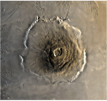
Mars is home to the largest volcano in the entire solar system, Olympus Mons.
At nearly 13.6 miles (22 kilometers) high, it towers three times taller than Mount Everest, and its base spans an area roughly the size of France.
Olympus Mons: The Giant That Dwarfs Earth
Olympus Mons is a shield volcano, built from repeated lava flows that spread outward in broad, gentle slopes. Unlike Earth’s volcanoes, which often erupt explosively, Mars volcanoes tend to ooze slow, steady lava.
That’s partly because Mars lacks plate tectonics. On Earth, the shifting plates move volcanoes off their heat sources, creating island chains like Hawaii. But on Mars, the crust stays still, allowing volcanoes like Olympus Mons to grow for millions of years in the same spot.
Imagine a mountain so tall it pierces the thin atmosphere, with slopes so gentle you could walk for days and barely feel the incline. Near the summit, a giant crater called a caldera stretches about 50 miles (80 kilometers) wide, a reminder of its last mighty eruptions that happened roughly 25 million years ago.
Even though it’s dormant now, Olympus Mons tells us that Mars once had a fiery heart and enough internal heat to power world-changing eruptions.
Tharsis Rise: The Volcanic Continent
Olympus Mons isn’t alone. It’s part of a vast volcanic plateau called the Tharsis region, a raised area stretching nearly 2,500 miles (4,000 kilometers) across.
Here you’ll find three other colossal volcanoes:
Arsia Mons
Pavonis Mons
Ascraeus Mons
Together, they form what’s known as the Tharsis Montes, towering peaks that dominate the western hemisphere of Mars.
NASA scientists believe that Tharsis is so massive it may have altered the entire planet’s orientation over time. The immense weight of its lava flows could have shifted Mars’ crust, changing the direction of its poles, a planetary “tilt” event unlike anything seen on Earth.
Elysium Region: The Lesser-Known Volcanoes
North of Tharsis lies another volcanic area called Elysium Planitia, home to Elysium Mons and Albor Tholus. These volcanoes are smaller but geologically younger, some areas may have experienced eruptions as recently as 2 million years ago.
That’s almost yesterday in geological time, suggesting Mars isn’t entirely dead. Some scientists even propose that Mars might still be volcanically active beneath its crust.
The European Space Agency’s Mars Express orbiter detected traces of recent lava flows, hinting that the Red Planet’s interior still stirs faintly.
Canyons That Could Swallow Continents
If volcanoes shaped Mars upward, canyons carved it downward. The most dramatic example is Valles Marineris, a canyon system so vast it makes the Grand Canyon look like a scratch on the surface.
Valles Marineris: The Canyon of Giants
Stretching over 2,500 miles (4,000 kilometers) long and up to 7 miles (11 kilometers) deep, Valles Marineris is the largest canyon in the solar system. If it were on Earth, it would stretch from New York to Los Angeles.
No single theory explains how it formed, but most scientists believe it began as a rift, a giant crack in the planet’s crust caused by the rise of the Tharsis volcanic region nearby. Over time, erosion, landslides, and perhaps even ancient water flow widened and deepened the chasm.
Images from NASA’s Mars Reconnaissance Orbiter show layered rock walls, evidence that water or wind erosion shaped its sides. Some regions even show mineral deposits left behind by evaporating water, suggesting this canyon once carried rivers or lakes.
Mars Canyons Beyond Valles Marineris
While Valles Marineris gets all the fame, Mars hosts other smaller canyons too, often formed by ancient water erosion.
Nanedi Vallis and Ares Vallis resemble dry river valleys on Earth, hinting that liquid water once carved their paths.
Dao Vallis near the Hellas Basin looks like a collapsed lava channel, formed when underground magma emptied and left the surface hollow.
These valleys, known collectively as outflow channels, paint a picture of a once-wet Mars where water rushed across the land long ago.
The Cratered Face of Mars
Look at Mars through a telescope, and you’ll notice its pockmarked surface. Like the Moon, Mars is covered with impact craters, scars from billions of years of asteroid and meteorite collisions.
The largest is Hellas Planitia, a giant basin more than 1,400 miles (2,300 kilometers) wide and 5 miles (8 kilometers) deep. It’s so large that it creates its own local weather patterns, trapping cold air and dust storms within its walls.
Other famous craters include:
Gale Crater, where NASA’s Curiosity rover landed in 2012. It contains layered sedimentary rocks that hold clues to Mars’ watery history.
Jezero Crater, the landing site of the Perseverance rover, where scientists found an ancient delta — a sign that a river once flowed into a lake there.
Each crater is a time capsule, preserving layers of Mars’ past like pages in a cosmic book.
Mars Mountains: Peaks from Fire and Impact
While Olympus Mons steals the spotlight, Mars has other fascinating mountains too. Some are volcanic, while others were formed by asteroid impacts or crustal uplifting.
Elysium Mons – A towering shield volcano, smaller than Olympus but still massive.
Arsia Mons – The southernmost of the Tharsis trio, once active for over 100 million years.
Noctis Labyrinthus – A maze-like mountain range at the western end of Valles Marineris, full of cliffs and fractures.
These ranges are silent now, but in their prime, they spewed lava, shook the ground, and perhaps even warmed the surrounding air — creating temporary microclimates where liquid water could exist.
The Story Hidden in Mars Soil
The Martian geology holds secrets that tell scientists how this planet lived, breathed, and changed.
Samples from the Curiosity and Perseverance rovers show that Mars soil contains basaltic rock, formed from cooling lava. In some areas, clays and sulfates suggest that water once interacted with rock, forming minerals that only appear in wet environments.
This discovery is one of the strongest evidence of water on Mars.
In Gale Crater, Curiosity found sediment layers that look like those formed in shallow lakes on Earth. The pattern of these layers suggests that water once filled the crater for millions of years before drying out.
If that water lasted long enough, it might have supported microbial life — one of the great scientific questions driving Mars exploration today.
The Lost Rivers of Mars
Long before it became a frozen desert, Mars had rivers that carved valleys, lakes that filled craters, and perhaps even a vast northern ocean.
Ancient Rivers
Images from orbiters show branching patterns called dendritic valleys, which form only from flowing liquid water. The most famous is Nirgal Vallis, a winding channel stretching hundreds of miles.
Lake Beds and Deltas
The Jezero Crater delta, explored by Perseverance, is a fossilized river mouth that once delivered sediments into a standing body of water. The layered rocks there hold organic molecules — potential biosignatures.
Northern Plains
Many scientists believe that billions of years ago, Mars’ northern hemisphere was once covered by an ocean the size of the Arctic. The smoother, lower terrain supports this theory, though the evidence is still debated.
Together, these features tell us that Mars once had a hydrological cycle — rivers, lakes, and rain. Today, only the ghosts of those waterways remain.
Winds That Shape a World
Even without liquid water, Mars is constantly reshaped by wind.
Powerful gusts sweep fine dust across the surface, forming dunes, ripples, and streaks. The Martian atmosphere, though thin, is still active enough to move sand grains, sculpting elegant patterns that shift with the seasons.
These dunes aren’t just pretty; they help scientists understand current weather conditions and how Mars is still evolving today.
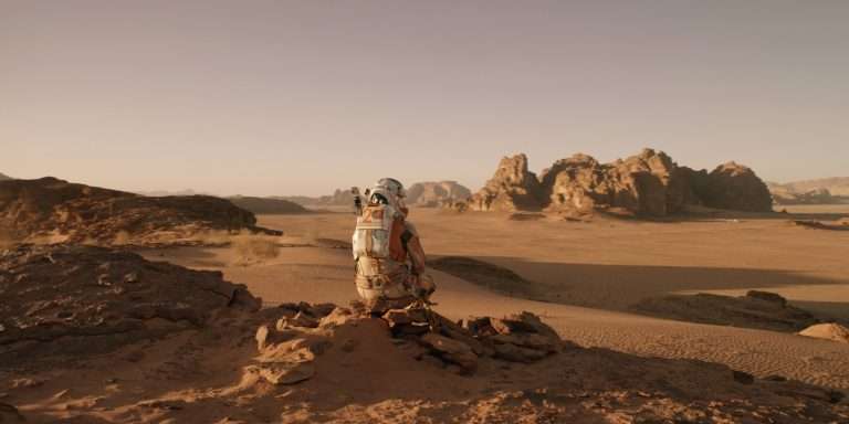
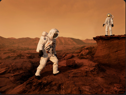
How Rovers See the Surface Up Close
Our understanding of Mars surface features comes from decades of exploration.
Viking 1 & 2 (1976): First detailed images of Martian soil and rocks.
Pathfinder & Sojourner (1997): Showed dust devils and pebble-strewn plains.
Spirit & Opportunity (2004): Found minerals formed in water.
Curiosity (2012–): Discovered ancient lakebeds and organic molecules.
Perseverance (2021–): Exploring an ancient river delta and collecting samples for return to Earth.
Each mission adds another chapter to Mars’ story — a story written in rock and dust.
Mars Surface at a Glance: Key Features Compared to Earth
| Feature | Mars Measurement / Example | Earth Equivalent |
|---|---|---|
| Highest Volcano | Olympus Mons – 22 km | Mount Everest – 8.8 km |
| Deepest Canyon | Valles Marineris – 11 km | Grand Canyon – 1.6 km |
| Largest Crater | Hellas Planitia – 2,300 km wide | South Pole-Aitken Basin – 2,500 km |
| Average Surface Temperature | -80°F (-60°C) | 59°F (15°C) |
| Surface Pressure | 610 Pa | 101,325 Pa |
| Dominant Rock Type | Basaltic | Basaltic (Earth’s ocean floors) |
| Evidence of Water | Ancient rivers & deltas | Active hydrological cycle |
What Mars’ Surface Tells Us About Its Past
The grand story of Mars is one of transformation — from fire to ice, from rivers to dust.
Billions of years ago, volcanic eruptions built towering mountains and reshaped continents. Later, water flowed, carving valleys and leaving behind minerals. Then, as the atmosphere thinned and the magnetic field faded, the planet dried up, freezing into silence.
But that silence is not the end. Beneath the dust, Mars still holds the records of its living past. With every rock drilled and every image captured, we’re piecing together a portrait of a once vibrant world.
The Future of Mars Surface Exploration
The next step in understanding Mars surface features will come from missions that dig deeper — literally.
ExoMars Rover (ESA): Scheduled to drill up to two meters below the surface to search for buried organic materials.
NASA’s Sample Return Mission: Will bring pieces of Mars back to Earth for laboratory analysis.
Human Missions (2030s and beyond): Astronauts may soon walk on these very plains, collecting samples from Olympus Mons slopes and the Valles Marineris rim.
Each of these missions will refine our understanding of Martian geology and maybe, just maybe, reveal whether life ever took hold in those ancient rivers.
A World That Mirrors Our Curiosity
Standing on the edge of Valles Marineris, looking across its endless cliffs, one thing becomes clear — Mars is not just another planet. It’s a mirror of human curiosity.
The volcanoes remind us of Earth’s restless energy. The canyons show the power of erosion and time. The dry riverbeds whisper of change, loss, and resilience.
In studying Mars, we don’t just learn about another world. We learn about our own — how fragile, dynamic, and beautiful it is.
Final Thought
The surface of Mars is a vast museum of cosmic history. Its volcanoes are ancient furnaces, its canyons are open wounds of time, and its riverbeds are the faint memories of a once-lively planet.
But what truly makes Mars breathtaking isn’t just its mountains or valleys — it’s how it makes us feel. Every rover track and every photo of its dusty horizon connects us to something bigger: our desire to explore, to understand, and to keep reaching for worlds beyond our own.
So the next time you gaze at the red glow of Mars in the night sky, remember — that tiny point of light holds mountains taller than any on Earth, valleys deeper than imagination, and stories written in stone waiting for us to read them.
References
National Geographic (2024). Mars: Volcanoes, Canyons, and the Lost Water of the Red Planet.
U.S. Geological Survey (USGS): Martian Surface and Volcanic Landforms Database.